Have you ever wondered what lies beneath the surface of the vast, blue expanse that covers most of our planet? The ocean depths, shrouded in darkness and mystery, hold secrets that have captivated explorers and scientists for centuries. But how do we actually study and map this hidden world? The answer lies in a collection of ingenious devices, each with its own unique abilities, that allow us to explore the ocean floor and unveil its secrets.

Image: www.studocu.com
Mapping the ocean floor is not just a scientific endeavor; it is crucial for a range of activities vital to our world. From laying underwater communication cables to guiding ships safely through treacherous waters, accurate and detailed maps are essential. Moreover, mapping the ocean floor provides invaluable insights into plate tectonics, climate change, and the distribution of marine life, enhancing our understanding of Earth’s complex systems.
Echolocation: Using Sound to See the Unseen
Sonar: The Pioneer of Underwater Mapping
The term “sonar” comes from the acronym “SOund Navigation And Ranging,” which perfectly captures its principle of operation. Sonar relies on sound waves to “see” objects underwater. It works by emitting sound pulses and then measuring the time it takes for the sound to bounce back after hitting an object, much like bats use echolocation to navigate their surroundings. Sonar technology revolutionized underwater exploration by offering a way to detect objects even in the dense, dark water.
Sonar systems come in various forms, each suited for different tasks. Active sonar transmits sound pulses and then analyzes the returning echoes, providing information about the distance, size, and shape of objects. Passive sonar, on the other hand, listens for sounds emitted by underwater objects, such as ships or marine animals, without transmitting its own signals.
Multibeam Sonar: A Revolution in Detailed Mapping
As sonar technology evolved, a breakthrough came with the development of multibeam sonar. This sophisticated system emits a fan of sound beams simultaneously, creating a much wider coverage area compared to traditional single-beam sonar. By scanning a large swath of the seafloor with multiple beams, multibeam sonar can generate detailed bathymetric maps — maps that depict the underwater topography.
The data collected by multibeam sonar is highly accurate and provides a comprehensive representation of the ocean floor. It has become the gold standard for marine surveying, assisting in the creation of detailed maps that are used for navigational safety, scientific research, and resource management.

Image: geo.libretexts.org
Beyond Sound: Other Tools for Ocean Floor Exploration
Remotely Operated Vehicles (ROVs): Eyes and Hands in the Depths
While sonar relies on sound waves to create images of the ocean floor, remotely operated vehicles (ROVs) provide a direct visual perspective. These robotic submersibles are tethered to a surface vessel and controlled remotely, allowing scientists to observe, collect samples, and even manipulate objects in the deep ocean. ROVs are equipped with cameras, sensors, and manipulator arms, making them versatile tools for a wide range of underwater tasks.
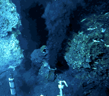
ROVs have played a crucial role in exploring and mapping underwater features, including deep-sea hydrothermal vents, shipwrecks, and coral reefs. Their ability to maneuver in complex environments and capture high-resolution images has revolutionized our understanding of the deep ocean.
Autonomous Underwater Vehicles (AUVs): Exploring Uncharted Territories
Taking underwater exploration a step further, autonomous underwater vehicles (AUVs) are robots capable of navigating and collecting data without human intervention. They are equipped with sensors, cameras, and navigation systems, allowing them to explore vast areas of the ocean floor independently.
AUVs are particularly valuable for mapping and surveying large, remote areas where human presence is limited or impractical. They have been deployed to create detailed maps of the ocean floor, study marine ecosystems, and even track underwater currents and pollution.
Satellite Altimetry: Mapping from Above
While sonar and submersibles explore the ocean floor from within the water, satellite altimetry provides a unique perspective, mapping the seafloor from above. This technique uses satellites equipped with radar altimeters to measure the height of the ocean surface. By carefully analyzing variations in sea surface height, scientists can deduce the shape of the ocean floor beneath.
Satellite altimetry is particularly useful for mapping vast areas of the ocean floor, especially in remote regions where other methods are less feasible. Its ability to cover large distances quickly makes it a valuable tool for global ocean mapping efforts.
The Future of Ocean Floor Mapping: Embracing Innovation
The field of ocean floor mapping is constantly evolving, driven by technological advancements and the increasing need for greater detail and accuracy. New technologies are emerging, such as the use of artificial intelligence (AI) to analyze vast datasets of oceanographic information and create more comprehensive maps.
Moreover, ongoing research is focused on optimizing existing technologies, improving the resolution and precision of data collected by sonar systems and underwater vehicles. The development of advanced sensors and navigation systems is also crucial for future exploration efforts.
By embracing innovation and pushing the boundaries of scientific exploration, we are unlocking the secrets of the ocean floor, gaining valuable insights into our planet and its intricate systems. The journey of mapping the ocean floor is a continuous expedition, a testament to human ingenuity and our unwavering quest to understand the wonders of the natural world.
A Device That Scientists Use To Map The Ocean Floor
Exploring Further:
This article provides just a glimpse into the fascinating world of ocean floor mapping. For those eager to delve deeper into this field, here are some resources to consider:
- National Oceanic and Atmospheric Administration (NOAA): Provides a wide range of information about ocean exploration and mapping, including maps, datasets, and research projects. (https://www.noaa.gov/)
- The Ocean Mapping Explorer: An online resource dedicated to ocean mapping, featuring news, articles, and information about various mapping technologies. (https://www.oceanmappingexplorer.com/)
- The International Hydrographic Organization (IHO): Responsible for standardizing hydrographic surveying and ocean mapping practices worldwide. (https://www.iho.int/)
I encourage you to explore these resources and continue your journey of discovery about the hidden mysteries beneath the waves.

:max_bytes(150000):strip_icc()/OrangeGloEverydayHardwoodFloorCleaner22oz-5a95a4dd04d1cf0037cbd59c.jpeg?w=740&resize=740,414&ssl=1)


